Cookies
O website necessita de alguns cookies e outros recursos semelhantes para funcionar. Caso o permita, o INESC TEC irá utilizar cookies para recolher dados sobre as suas visitas, contribuindo, assim, para estatísticas agregadas que permitem melhorar o nosso serviço. Ver mais
Aceitar Rejeitar
  • Menu
Sobre

Sobre

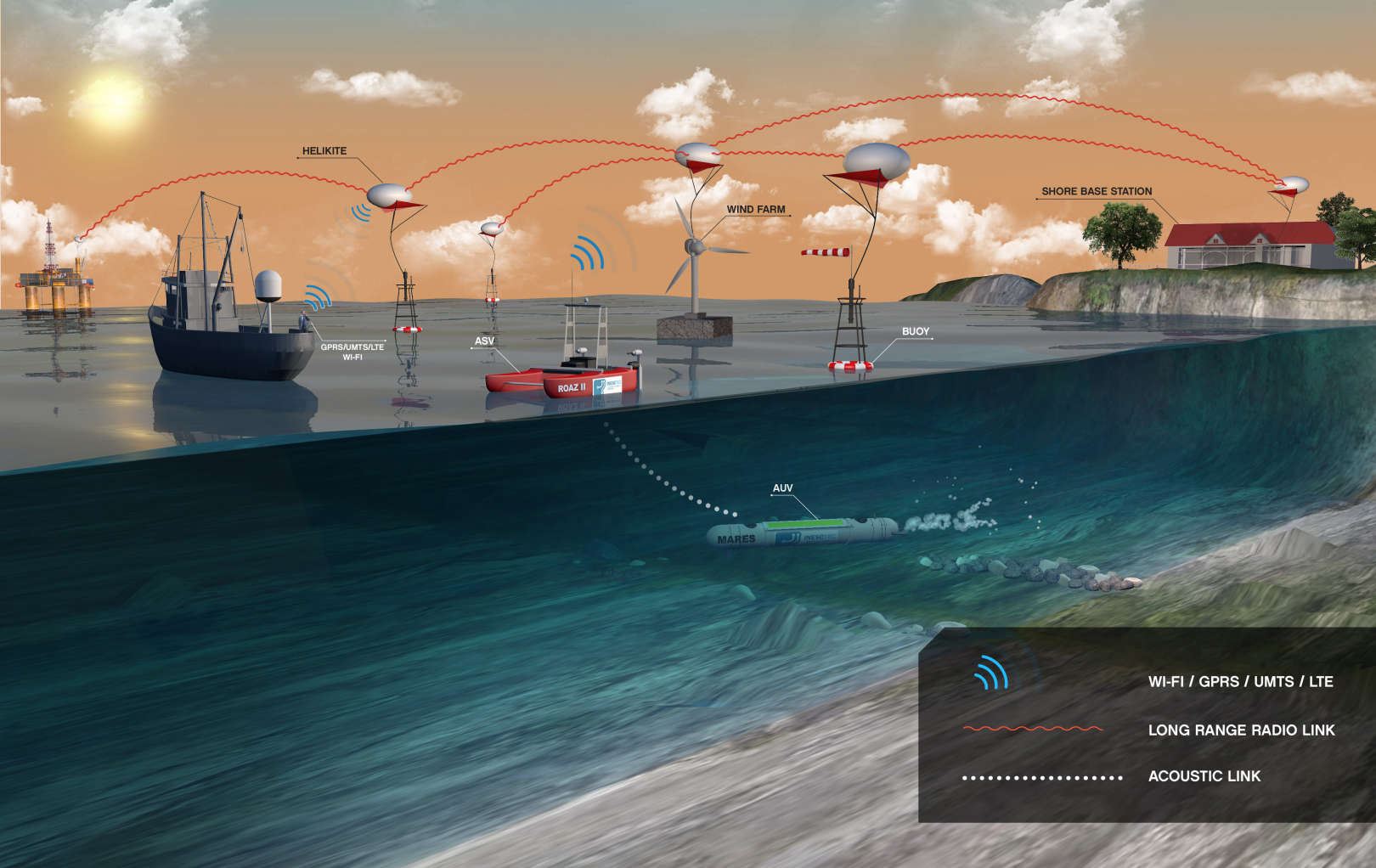
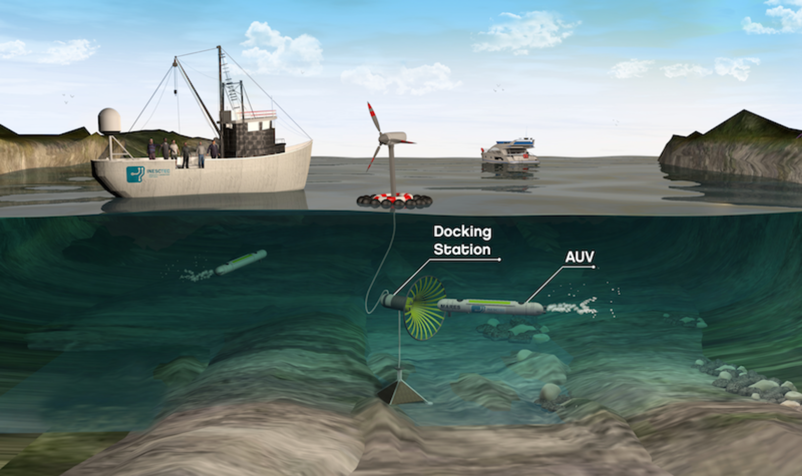
Sou Investigador Sénior no centro de Róbotica e Sistemas Autónomos do INESC TEC. Formei-me na Faculdade de Engenharia da Universidade do Porto em Engenharia Electrotécnica e de Computadores, primeiro com o grau de mestre, em 2009, e depois com o grau de doutor, em 2014. Desde 2009, estou ligado à Robótica Submarina e de Superfície investigando em Controlo, Condução (guidance), Localização e Coordenação de robots marítimos.

As minhas atividades têm sido desenvolvidas no âmbito de diversos projectos nacionais e internacionais dos quais se destacam o projeto Lajeado (AUV para monitorização de barragens), o FP7 ICARUS (Integrated Components for Assisted Rescue and Unmanned Search operations) e o FLEXUS (Flexible Unmanned Surface vehicles for the Internet of moving things), financiado pelo projeto H2020 RAWFIE.

Estou ainda envolvido no desenvolvimento de vários sistemas robóticos e na origem de vários protótipos tais como o veículo de superfície autónomo FLEXUS e o veículo submarino autónomo SHAD.

Tópicos
de interesse
Detalhes

Detalhes

  • Nome

    Bruno Miguel Ferreira
  • Cargo

    Investigador Sénior
  • Desde

    01 janeiro 2010
  • Nacionalidade

    Portugal
  • Contactos

    +351228340554
    bruno.m.ferreira@inesctec.pt
013
Publicações

2024

Probabilistic Positioning of a Mooring Cable in Sonar Images for In-Situ Calibration of Marine Sensors

Autores
Oliveira A.J.; Ferreira B.M.; Cruz N.A.; Diamant R.;

Publicação
IEEE Transactions on Mobile Computing

Abstract
The calibration of sensors stationed along a cable in marine observatories is a time-consuming and expensive operation that involves taking the mooring out of the water periodically. In this paper, we present a method that allows an underwater vehicle to approach a mooring, in order to take reference measurements along the cable for in-situ sensor calibration. We use the vehicle's Mechanically Scanned Imaging Sonar (MSIS) to identify the cable's reflection within the sonar image. After pre-processing the image to remove noise, enhance contour lines, and perform smoothing, we employ three detection steps: 1) selection of regions of interest that fit the cable's reflection pattern, 2) template matching, and 3) a track-before-detect scheme that utilized the vehicle's motion. The later involves building a lattice of template matching responses for a sequence of sonar images, and using the Viterbi algorithm to find the most probable sequence of cable locations that fits the maximum speed assumed for the surveying vessel. Performance is explored in pool and sea trials, and involves an MSIS onboard an underwater vehicle scanning its surrounding to identify a steel-core cable. The results show a sub-meter accuracy in the multi-reverberant pool environment and in the sea trial. For reproducibility, we share our implementation code.

2023

Estimation of Sediments in Underwater Wall Corners using a Mechanical Scanning Sonar

Autores
Goncalves, CF; Cruz, NA; Ferreira, BM;

Publicação
2023 IEEE UNDERWATER TECHNOLOGY, UT

Abstract
This paper describes a robotic system to detect and estimate the volume of sediments in underwater wall corners, in scenarios with zero visibility. All detection and positioning is based on data from a scanning sonar. The main idea is to scan the walls and the bottom of the structure to detect the corner, and then use data obtained in the direction of the corner to estimate the presence of sediment accumulation and its volume. Our approach implements an image segmentation to extract range from the surfaces of interest. The resulting data is then employed for relative localization and estimate of the sediment accumulation. The paper provides information about the methodologies developed and data from practical experiments.

2023

Single Receiver Underwater Localization of an Unsynchronized Periodic Acoustic Beacon Using Synthetic Baseline

Autores
Ferreira, BM; Graça, PA; Alves, JC; Cruz, NA;

Publicação
IEEE JOURNAL OF OCEANIC ENGINEERING

Abstract
This article addresses the 3-D localization of a stand-alone acoustic beacon based on the Principle of Synthetic Baseline using a single receiver on board a surface vehicle. The process only uses the passive reception of an acoustic signal with no explicit synchronization, interaction, or communication with the acoustic beacon. The localization process exploits the transmission of periodic signals without synchronization to a known time reference to estimate the time-of-arrival (ToA) with respect to an absolute time basis provided by the global navigation satellite system (GNSS). We present the development of the acoustic signal acquisition system, the signal processing algorithms, the data processing of times-of-arrival, and an estimator that uses times-of-arrival and the coordinates where they have been collected to obtain the 3-D position of the acoustic beacon. The proposed approach was validated in a real field application on a search for an underwater glider lost in September 2021 near the Portuguese coast.

2023

Sensor Placement in an Irregular 3D Surface for Improving Localization Accuracy Using a Multi-Objective Memetic Algorithm

Autores
Graca, PA; Alves, JC; Ferreira, BM;

Publicação
SENSORS

Abstract
Accurate localization is a critical task in underwater navigation. Typical localization methods use a set of acoustic sensors and beacons to estimate relative position, whose geometric configuration has a significant impact on the localization accuracy. Although there is much effort in the literature to define optimal 2D or 3D sensor placement, the optimal sensor placement in irregular and constrained 3D surfaces, such as autonomous underwater vehicles (AUVs) or other structures, is not exploited for improving localization. Additionally, most applications using AUVs employ commercial acoustic modems or compact arrays, therefore the optimization of the placement of spatially independent sensors is not a considered issue. This article tackles acoustic sensor placement optimization in irregular and constrained 3D surfaces, for inverted ultra-short baseline (USBL) approaches, to improve localization accuracy. The implemented multi-objective memetic algorithm combines an evaluation of the geometric sensor's configuration, using the Cramer-Rao Lower Bound (CRLB), with the incidence angle of the received signal. A case study is presented over a simulated homing and docking scenario to demonstrate the proposed optimization algorithm.

2023

TEC4SEA-Developing maritime technology for a sustainable blue economy

Autores
Monica, P; Cruz, N; Almeida, JM; Silva, A; Silva, E; Pinho, C; Almeida, C; Viegas, D; Pessoa, LM; Lima, AP; Martins, A; Zabel, F; Ferreira, BM; Dias, I; Campos, R; Araujo, J; Coelho, LC; Jorge, PS; Mendes, J;

Publicação
OCEANS 2023 - LIMERICK

Abstract
One way to mitigate the high costs of doing science or business at sea is to create technological infrastructures possessing all the skills and resources needed for successful maritime operations, and make those capabilities and skills available to the external entities requiring them. By doing so, the individual economic and scientific agents can be spared the enormous effort of creating and maintaining their own, particular set of equivalent capabilities, thus drastically lowering their initial operating costs. In addition to cost savings, operating based on fully-fledged, shared infrastructures not only allows the use of more advanced scientific equipment and highly skilled personnel, but it also enables the business teams (be it industry or research) to focus on their goals, rather than on equipment, logistics, and support. This paper will describe the TEC4SEA infrastructure, created precisely to operate as described. This infrastructure has been under implementation in the last few years, and has now entered its operational phase. This paper will describe it, present its current portfolio of services, and discuss the most relevant assets and facilities that have been recently acquired, so that the research and industrial communities requiring the use of such assets can fully evaluate their adequacy for their own purposes and projects.

Teses
supervisionadas

2023

Information-aware Feature-based Underwater Localization and Planning

Autor
António José Ventura de Oliveira

Instituição
UP-FEUP

2023

Dynamic Reconfiguration of Underwater Acoustic Systems for Enhanced Localization via Active Perception

Autor
Paula Alexandra Agra Graça

Instituição
UP-FEUP

2023

Digitizing Patient Preferences in Palliative Care: A Step towards Personalized Care

Autor
João Luís Pereira Ferreira

Instituição
UP-FEUP

2022

Mapeamento e Localização Subaquática em Mapas Densos

Autor
Paulo Miguel Alves Gonçalves

Instituição
UP-FEUP

2022

Collaborative Tools for Lung Cancer Diagnosis in Computed Tomography

Autor
Carlos Alexandre Nunes Ferreira

Instituição
UP-FEUP